9.7 Earthquake Coming to West Coast On October 3, 2013

Opmmur

Time Travel Professor
Messages
5,049
9.7 Earthquake Coming to West Coast On October 3, 2013

Three independent sources have recently claimed the Lord told them a large earthquake is going to hit the west coast on Thursday, October 3, 2013. Two of these sources identified the earthquake will measure 9.7 on the Richter scale. That would make it the largest earthquake in recorded history.

Since 1900 when earthquake records began, the largest earthquake was 53 years ago, a 9.5 in Chile in 1960. That earthquake was also accompanied by a 38 foot tsunami, which caused most of the casualties. There have only been five earthquakes in history measuring 9.0 or higher, so it is very rare.

It is also rare for the Lord to give people specific dates and Richter scale measurements for these events. Usually people only see scenes from what is coming, but no dates. So to hear three independent sources all hearing the same date makes this all very unusual.

According to these sources, the Golden Gate Bridge will be broken in half by the tsunami. The remains of the bridge will be moved into a vertical position. The San Francisco valley will be flooded with water. The following provides testimonies from each of these three sources. [Continue reading at Z3news.com]
 

Opmmur

Time Travel Professor
Messages
5,049
US Nuclear Reactors vs Fault Line Map: This Map Shows Where Earthquakes Could Result in Nuclear Nukes in the USA
Posted by admin on 24 July 2013 under Earthquake, Tremor, Nuclear Threat

A lot of tumult has been taking place here in America over the nuclear crisis unfolding in Japan. And, I bet that sometimes you are wondering about the earthquake-related nuclear devastation the US could face in case of an earthquake having the magnitude of the 2011 Japan quake which lead to the almost complete disruption of the Fukushima Daiichi nuclear plant.


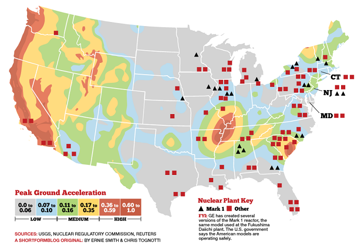
This map presents the position of the US nuclear reactors (Reuters and NRC) superimposed on a map of the earthquake risk as measured by “Peak Ground Acceleration” (PGA) which matches with that of the US fault lines (USGS).

The map tells the tale:
  • 23 US plants are presently using a Mark 1 (boiling water reactors) reactor, the same technology which was involved in the Fukushima Daiichi nuclear disaster in Japan. All are in the eastern half of the country (source).
  • There are also eight nuclear power plants located along the seismically active West coast.
  • Twelve of the American reactors that are of the same vintage as the Fukushima Daiichi plant are in seismically active areas.
The PGA risk is what is typically used to set building codes. Most nuclear power plants are designed to operate under 0.2g PGA, and automatically shut off if the PGA exceeds 0.2g. Remember this earthquake that shut down a nuclear plant on the US east coast!

The following nuclear power plants have a two percent or greater chance of having PGA over 0.15g in the next 50 years: Diablo Canyon, Calif.; San Onofre, Calif.; Sequoyah, Tenn.; H.B. Robinson, SC.; Watts Bar, Tenn.; Virgil C. Summer, SC.; Vogtle, GA.; Indian Point, NY.; Oconee, SC.; and Seabrook, NH.

The bottom line is that a major earthquake would probably not result in a nuclear meltdown at the reactors on the above map, but it could present significant engineering challenges.

The Link: US Nuclear Reactors vs Fault Line Map: This Map Shows Where Earthquakes Could Result in Nuclear Nukes in the USA | Strange Sounds
 

Giorgio Armani

Junior Member
Messages
68
9.7 Earthquake Coming to West Coast On October 3, 2013

Three independent sources have recently claimed the Lord told them a large earthquake is going to hit the west coast on Thursday, October 3, 2013. Two of these sources identified the earthquake will measure 9.7 on the Richter scale. That would make it the largest earthquake in recorded history.

Since 1900 when earthquake records began, the largest earthquake was 53 years ago, a 9.5 in Chile in 1960. That earthquake was also accompanied by a 38 foot tsunami, which caused most of the casualties. There have only been five earthquakes in history measuring 9.0 or higher, so it is very rare.

It is also rare for the Lord to give people specific dates and Richter scale measurements for these events. Usually people only see scenes from what is coming, but no dates. So to hear three independent sources all hearing the same date makes this all very unusual.

According to these sources, the Golden Gate Bridge will be broken in half by the tsunami. The remains of the bridge will be moved into a vertical position. The San Francisco valley will be flooded with water. The following provides testimonies from each of these three sources. [Continue reading at Z3news.com]
i dont believe it will happen
 

TnWatchdog

Senior Member
Messages
7,099
I don't know if a quake will happen on the exact date but it will happen sooner than later. The big one is overdue and will spawn other big ones. Thanks for the info opmmur and Sam. North Dakota would be a good place to live, except for being so cold. I've been there and know it would be a great place to avoid hungry crowds.
 

Giorgio Armani

Junior Member
Messages
68
I don't know if a quake will happen on the exact date but it will happen sooner than later. The big one is overdue and will spawn other big ones. Thanks for the info opmmur and Sam. North Dakota would be a good place to live, except for being so cold. I've been there and know it would be a great place to avoid hungry crowds.
This earth quake will not happen because you are being given false information. I had a dream of japans earthquake and it happened. Had a dream of twin towers and the tsanami that killed 200,000 thosuand people and it came true. So this is why I dont believe this 9.7 is gona happen here on the westcoast
 

Opmmur

Time Travel Professor
Messages
5,049
I believe this event will happen in the month of October.
But not as powerful as first stated.
 

Num7

Administrator
Staff
Messages
12,442
We're going to find out pretty soon if your sources are right, professor.
 

Opmmur

Time Travel Professor
Messages
5,049
Satellites reveal new views of Pakistan's 'Earthquake Island'
Becky Oskin LiveScience


8C9246731-131001-science-quake-530p.blocks_desktop_large.jpg

AFP - Getty Images

An image from the Pleiades satellite shows a small island of mud and rock created by the huge earthquake that hit southwest Pakistan. The island is about 60 to 70 feet (18 to 21 meters) high and more than 500 feet (150 meters) in diameter. It sits about 650 feet from the coast.
Earth performed the ultimate magic trick last week, making an island appear out of nowhere. The new island is a remarkable side effect of a deadly Sept. 24 earthquake in Pakistan that killed more than 500 people.

Satellite images snapped a few days after the earthquake-triggered island emerged offshore, near the town of Gwadar, reveal that the strange structure is round and relatively flat, with cracks and fissures like a child's dried-up mud pie.

The French Pleiades satellite mapped the muddy hill's dimensions, which measure 576.4 feet (175.7 meters) long by 524.9 feet (160 m) wide. Aerial photos from Pakistan's National Institute of Oceanography suggest the gray-colored mound is about 60 to 70 feet (18 to 21 meters) high. [Gallery: Amazing Images of Pakistan's Earthquake Island]

Gwadar is about 230 miles (380 kilometers) from the earthquake's epicenter. The magnitude-7.7 earthquake was probably centered on the Chaman Fault, Shuhab Khan, a geoscientist at the University of Houston told LiveScience last week.

Geologists think the new island, named Zalzala Koh, is made of erupted mud, spewed from the seafloor when either trapped gases escaped or subsurface water was violently expelled.

8C9246732-131001-science-gwadar1.blocks_desktop_large.jpg

NASA

On Sept. 26, the Advanced Land Imager on NASA's Earth Observing-1 satellite captured an image of Pakistan's new island.
8C9246287-131001-science-gwadar2.blocks_desktop_large.jpg

Pakistan National Institute of Oceanography via NASA

An aerial photo from Pakistan's National Institute of Oceanography suggests the gray-colored mound is about 60 to 70 feet (15 to 20 meters) tall. The surface is covered in sea creatures such as dead fish and is a mixture of mud, sand and rock. It is solid enough for people to walk on. Boats can be seen surrounding the island.

The new island could be the result of a mud volcano. Mud volcanoes form when hot water underground mixes with sediments and gases such as methane and carbon dioxide. If the noxious slurry finds a release valve, such as a crack opened by earthquake shaking, a mud volcano erupts, according to James Hein, a senior scientist with the U.S. Geological Survey in Santa Cruz, Calif. Geologists from the Pakistan Navy report that Zalzala Koh is releasing flammable gas. But seafloor sediments commonly hold methane-producing bacteria, so the possible methane coming from the island isn't a clincher to its identity.

Shaking from the powerful Sept. 24 earthquake could have also loosened the seafloor sediments offshore of Pakistan, jiggling them like jelly. The great rivers coming down from the Himalayas dump tons of water-saturated sediment into the Arabian Sea every year. The new island could be a gigantic example of a liquefaction blow, when seismic shaking makes saturated sediments act like liquid, and trapped water suddenly escapes, Michael Manga, a geophysicist at the University of California, Berkeley, told LiveScience.

Similar islands have appeared offshore of Pakistan after strong earthquakes in the region in 2001 and 1945. If the earlier examples hold, the soft mud island won't last a year, disappearing under the erosive power of the pounding of waves from monsoon storms.
 

Top