Hi folks,
Are we all familiar with the cartesian coordinates system (x,y)?
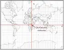
On the appropriate Mercator projection of Earth, it will appear like in the picture below.

The builders of the pyramids mark the origin (0,0) with a lake big enough to be seen from space: Lake Victoria in Africa.
(x,y)
x will represent the longitude in degree minute second north or south, with maximum value 90 00'00" north or south
y will represent the latitude in deg min sec east or west, with maximum value 180 00'00" east or west
With that in hand you can go and watch the code peacefully:
a monument should reflect its coordinates (x,y)
Are we all familiar with the cartesian coordinates system (x,y)?
On the appropriate Mercator projection of Earth, it will appear like in the picture below.

The builders of the pyramids mark the origin (0,0) with a lake big enough to be seen from space: Lake Victoria in Africa.
(x,y)
x will represent the longitude in degree minute second north or south, with maximum value 90 00'00" north or south
y will represent the latitude in deg min sec east or west, with maximum value 180 00'00" east or west
With that in hand you can go and watch the code peacefully:
a monument should reflect its coordinates (x,y)
